

LOCATED in the north central portion of the U.S. state of Georgia. As of the 2010 census, the population was 22,330. The county seat is Dawsonville. Dawson County is included in the Atlanta-Sandy Springs-Roswell, GA Metropolitan Statistical Area. Its natural resources include AMICALOLA FALLS,
the highest in Georgia and one of the
Seven Natural Wonders of the state.

Created on December 3, 1857 from Gilmer and
Lumpkin counties. It is named for William Crosby Dawson, a U.S. Senator from Georgia. Civil War: The 1860s brought war and hardships to the people of Dawson County. Many men of Dawson County answered the call and went to fight in the CIVIL WAR. Post Civil War to present: The county is known in auto racing circles for its long tradition of involvement in the sport,which was established in the 20th century; many of the original NASCAR racers came from this area.


Local racing skills are said to have been developed by men who ran moonshine down highway 9, also known as Thunder Road, to Atlanta. Celebrations of Dawson County’s history and of its “likker” involvement occur every October with the MOONSHINE FESTIVAL.
Locals have referred to Dawson County as the Moonshine Capital of the World. This title is claimed by many other areas but is fiercely defended by residents of this area. They took advantage of its relative isolation and the ability to move so much moonshine to the larger cities, especially Atlanta, during the Prohibition era.

Dawson County currently serves grades K-12.
It has a total of 8 schools: one for Pre-K, four for grades K-5, one for grades 6-7, one for grades 8-9, and a high school for grades 10-12.
Dawson Head Start Pre-K
Blacks Mill Elementary School (K-5)
Robinson Elementary School (K-5)
Kilough Elementary School (K-5)
Riverview Elementary School (K-5)
Dawson County Middle School (6-7)
Dawson County Junior High School (8-9)
Dawson County High School (10-12)


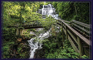
According to the U.S. Census Bureau, the county has a total area of 214 square miles (550 km2), of which 211 square miles (550 km2) is land and 3.6 square miles (9.3 km2) (1.7%) is water. Part of LAKE LANIER is in the southeastern part of the county and the boundary line with neighboring counties pass through the lake. The 729-foot (222 m) Amicalola Falls, are located in the county.
The Amicalola Falls are the highest in Georgia,
the tallest cascading waterfall east of the Mississippi River, and one of the Seven Natural WONDERS of Georgia. The highest point in the county is Black Mountain, with an elevation of 3,600 feet (1,100 m). 6,760 acre (27.4 km2), which is located in the Chattahoochee National Forest.
The Chestatee and Etowah rivers flow through Dawson County. The VAST majority of Dawson County is located in the Etowah River sub-basin of the ACT River Basin (Coosa-Tallapoosa River Basin). The southeastern tip of the county is located in the upper Chattahoochee River sub-basin of the ACF River Basin (Apalachicola-Chattahoochee-Flint River Basin), and
a very small northern section of Dawson County is located in the Coosawattee River sub-basin of the larger ACT River Basin.[5]
ADJACENT COUNTIES
-Fannin County – north
-Lumpkin County – northeast
-Hall County – east
-Forsyth County – south
-Cherokee County – southwest
-Pickens County – west
-Gilmer County – northwest
National protected area
-Chattahoochee
National Forest (part)
Copyright © 2018 The Faces Of L.L.C., All Rights Reserved.
For information on a License Partnership for The Faces of Your Town email - brad@thefacesof.com